Month: June 2020

Once Upon A Time…

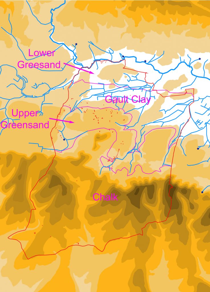
For this blog I have decided to go back right to the beginning, to the very earliest evidence we have of people getting up to stuff in what was later to become the parish of Harting. The best source of information for these earlier periods is the data held within what is called the “Historic Environment Record” (HER). This database, and others like it, are held by the heritage departments of local authorities, usually at a County or Unitary Council level, but occasionally at District, as is the case for Chichester. Anyone is entitled to ask for the information they hold, free of charge if it is for private research. The entry point for the Chichester District Council HER can be found at: https://www.chichester.gov.uk/article/25592/Historic-Environment-Record-HER

While these databases hold a lot of information about the past, they are obviously limited by what has been reported to them, and that in turn is limited by what has been found. So there is a lot of information out there held by individuals who have never reported what they know or have found, and then there is a far greater amount of evidence that has never been found at all, but awaits either discovery (below the ground), or recognition (above the ground). So while HERs are a great central holding place for data (I would urge any of you who know things, or have found things, to get in touch with them to report it, so that we can all benefit from your knowledge), what they offer is, in their very nature, only very partial snapshot into the past.

The earliest phase of activity that our Harting HER data relates to is the Stone Age, since this is the first of the material-themed ages used to divide up our prehistoric past. The stone age is then sub-divided into the Paleolithic, Mesolithic and Neolithic. “Paleo” is Greek for “old”, “Meso” for “middle” and “Neo” for “new”, with “lithic” meaning “stone”. So essentially you have the “old stone age”, “middle stone age” and “new stone age”. And it was called the “Stone Age” for a reason – the reason being that things were made out of stone, rather than the metals that later ages are named after (Bronze and then Iron). And it is these stone objects, usually made of flint, that constitute pretty much the only evidence we find of the activities of those that made them, for their other possessions were of much less durable material, such as leather, wood and bone (fired clay objects, such as pot, were not known to them)

If I can oversimplify things somewhat, in the first two (the “old” & “middle”) people generally moved around a fair bit, not setting up shop for too long in any one place, as they travelled around looking for sustenance. In the last (the “new”, starting c. 4,000 BC) things settled down, with the development of farming, which tied people much more to one place. This inevitably means that the remains left behind by Paleolithic and Mesolithic visitors to Harting are rather less substantial and numerous than their later more settled successors. And this is reflected in the archaeological data we have.

Sum total of Paleolithic & Mesolithic records in Harting parish in the Chichester District Council HER, shown as purple dots

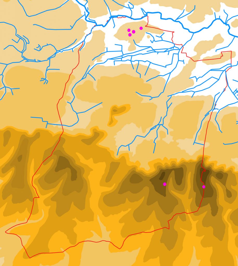
The map above shows all the records that the HER holds for Paleolithic and Mesolithic activity in Harting parish – not much as you can see. The upper four dots on the map represent a Paleolithic flint handaxe, and three records of Mesolithic worked flints, found at West Heath sand quarry. The lower two dots are Mesolithic worked flints from Round Down and Beacon Hill.

But before we write the neighbourhood off as of little or no interest to our hunter-gatherer predecessors, we need to remember the comments I made earlier about the fragmentary nature of the evidence we hold. I would imagine that there are almost certainly many more Paleolithic and Mesolithic flints from Harting squirrelled away in people’s houses, sometimes perhaps unrecognised for what they are, that have been picked up on walks or while digging the ground (do get in touch if you wish to let me know of any, or just contact the HER). But there will also be a vast number of other flints still awaiting discovery. So taking all this into consideration, it would be very unwise to draw any conclusions about where people might have roamed in those far off ages based upon the six findspots recorded above. Although one point might be worth making, which is that, at least in Mesolithic times, our predecessors were wont to roam both down by the Rother and up on the Downs.

Next time I will move on to look at the last phase of the Stone Age (the Neolithic) and the beginnings of the metal ages (the Early Bronze Age – when barrows ruled the land).

Deer Parks

Deer parks were comparatively common in the medieval period, and were owned by a wide variety of individuals, including the monarch and the titled aristocracy, but also archbishops and bishops, and the more minor gentry. Harting seems to have been particularly well served with such parks, the medieval lords of Harting, the Husseys, possessing three, which together totalled about 20% of the land area of the parish.

The three medieval deer parks of Harting (shaded red). The parish boundary is shown as a red line.

As the name suggests, the principal purpose of these parks was to hold deer, acting as a sort of “live” larder. There seems to have been a fairly consistent ratio of acres to deer, at least in West Sussex, with the parks of the Earls of Arundel containing roughly one deer per acre (1.1 to be precise). We do not currently have the figures for the number of deer in the Harting parks, but presuming the ratio holds true, and that it was a deliberate figure based upon what they considered at the time your average deer in such parks needed, then the total number of deer in the parish would have been about 1,700.

We tend to have fond notions, based on the movies, about medieval lords going out hunting on a regular basis, on horseback and armed with spears, to kill deer in these parks . But it is far more likely that the killing of the deer in these parks was more often done by the park servants, using cross-bows, whenever venison was required. And, to spoil our imaginary picture even more, it is more probable that when the lords did go hunting, they did so as much using cross-bows as spears, and on foot, as on horses. It may well have had a lot more in common with a modern-day pheasant shoot, than a fox-hunt, with the deer being driven past a number of “stands” behind which lurked an aristocratic huntsman with his trusty 12-bore cross-bow.

The medieval Overpark, shown over the modern Ordnance Survey 1:25000 Explorer map © Crown copyright. All rights reserved. License number: AL100036068

The largest of the three Harting parks is what is now called Uppark, but was in the past known as Overpark or Outrepark. This was situated wholly upon the Downs, and contained something in the region of 900 acres, if its extent on the 1808 map is an accurate record of its medieval size. As with all deer parks, there would have been a hunting lodge within its bounds, most probably on the site of the existing mansion, which was itself built in 1685/6. This lodge would have served as the everyday base of the park keeper, but also as the place to stay for the lord and his guests should they come to hunt. In some cases, as at Downley Park, near Singleton, the lord could turn it into a second home on a more permanent basis. These hunting lodges often went on to become farms or even stately homes when the parks were “disemparked” in the post-medieval period, as happened at Uppark. One of the problems with the park at Uppark would have been water, which was obviously a major issue when you had large herds of deer to look after. There are no natural water sources within the park, and so it had to be supplied in some other way, possibly partly through rain-fed ponds, but also manually from wells. There is such a well, know appropriately as “Keepers Well” within the park. It is also possible that the deer were driven into the neighbouring Home Park, which was separated from it only by the current Uppark road, should things have got desperate.

The medieval Home Park, shown over the modern Ordnance Survey 1:25000 Explorer map © Crown copyright. All rights reserved. License number: AL100036068

As has just be mentioned, Uppark bordered onto the second of the Harting Parks, that situated adjacent to the manor house and church of South Harting. This was variously known as “Home Park”, “Old Park” or “Middle Park”. It was a much smaller park, presumably because land on the Upper Greensand shelf was much more in demand for cultivation than that elsewhere within the parish. It extended from the current Petersfield road, up to the South Downs Way, being bounded by the Uppark road on one side, and the road to Foxcombe on the other. Altogether it enclosed about 250 acres, and presumably held a similar number of deer (c.275 on the above ratio). Here a hunting lodge was unnecessary, since the manor house and its outbuildings would have served that purpose, sited as they were just within the parks eastern limit. Water was also not a problem, since, as we have already seen in previous blogs, the main eastern stream of the parish began its life within the park.

The medieval Down Park, shown over the modern Ordnance Survey 1:25000 Explorer map © Crown copyright. All rights reserved. License number: AL100036068

The third and final medieval deer park lay within the northern part of the parish, and was called “Down Park” or “Nether Park” (“nether” being an old word for “lower”). As the name suggests, this park lay in the lowest part of the parish, and certainly did not suffer from water problems. The c.480 deer within its 440 acres would have been well watered by the major West Harting stream and its tributaries, as it meandered through the northern part of the park. Here a hunting lodge would have been required, and it was almost certainly located at Parlour Copse, were a small moat encloses its site. Small-scale excavation of this, back in the mid-20th century, revealed the remains of a timber bridge and significant quantities of roof tiles and pottery dating from the medieval period. This hunting lodge went on to become the main residence of one of the Hussey descendants in the 16th century. As with Home Park, this park may well have also contained a mill, fed by Harting Pond, which itself lay just outside the park to the west. As with all the parks, the idea was that the deer were kept securely inside and not allowed to escape. This was achieved by putting up a fence, called a “pale”, around its entire circuit. The fence was mounted upon a bank, with an internal ditch, to provide enough height to stop the deer leaping over it. Traces of the bank, and occasionally the ditch, if it has not been subsequently infilled, can often still be found around the edges of these deer parks, as is the case with Down Park.

There was a fourth deer park in the parish, but since this was not formed until the 17th century, it is not covered by this blog. It was located on the Downs in the south-western corner of the parish, and surrounded the late 17th century mansion of Ladyholt, once the seat of the Caryll family, and the rival of Uppark, but sadly demolished only a century after its construction.

The Naked Landscape

Writing on water for the last blog post has got me onto thinking about the landscape more generally. A good way to get your head around how a particular locality might have been lived in over the centuries is to strip out all the works of mankind and start again with a blank canvas. The bare bones of a landscape are essentially the topography (i.e. the hills, valleys, plains etc.), the water (springs, streams, rivers) and the geology (what is beneath the ground). Everything above that, particularly in an intensively inhabited place like England, is going to be either created or planted by people.

I find the easiest way to do that is to get hold of an Ordnance Survey Explorer 1:25,000 map (the common walking map) which has the contour lines marked on it, and then just trace over the contours (you can do this digitally or manually). That will give you the topography. You can then also trace over the springs, streams and rivers, which will give you the water. For the geology, we are blessed with the British Geological Survey, whose website contains a “Geology Viewer” which plots all the different geologies in the UK, and you can again just trace them off as appropriate (http://mapapps.bgs.ac.uk/geologyofbritain/home.html?)

When you have finished doing this you will end up with something like this:

Topographic map of Harting parish (outlined in red), showing the contours, water (the blue stars are springs) and geology (boundaries marked in purple)

This exercise presents you with a picture of what the first settlers would have encountered, when they turned up, in terms of the “base layers”. Obviously the vegetation above is not so easily demonstrated, since we simply do not have enough data to be certain of what it looked like. The traditional view was that the whole lot was covered by trees, before man came and cut them all down, but voices have been raised to question this, and it is not impossible that the landscape was in fact rather more varied, with potentially quite large open spaces grazed by herds of animals.

Returning to the three elements of our base map, we will start with geology. Harting, like many of the Sussex parishes, has a wonderfully mixed collection of geologies, with the chalk Downs in the south, sloping steeply down to the shelf of Upper Greensand upon which the villages of West, South and East Harting sit, which in turn dips down to the Gault Clay, with Nyewood upon it, and finally the Lower Greensand, through which the River Rother meanders.

Each of these geologies has its own characteristics, but the main interest for us is those that effect what people do. The chalk is well-drained, with generally thin, easy to cultivate soils. The Upper Greensand is moderately well-drained (there is a varying clay content) and the soils are more fertile. The Gault clay is generally pretty horrible, being too wet in winter and too dry in summer, because of its poor drainage. The Lower Greensand is well-drained, and of middling fertility.

A glimpse at the Google Earth aerial photos will give you a pretty good idea of how farmers now use these different soils, so you will see mainly pasture over the highest Chalk slopes and over the Gault Clay, and then mainly arable over the Upper Greensand and lower southern chalk slopes. The Lower Greensand is slightly more mixed, with some arable and some pasture. While we have to make some allowance for improved methods of ploughing and more effective fertilisers, modern use is not a bad guide to past use, and it seems likely that back in the day cultivation followed roughly the same pattern. The one exception seems to have been that the thin chalk soils on the upper slopes of the Downs were more heavily used for cultivation, probably because they were easier to plough, but we will return to that in a later blog.

It is striking also to note that the vast majority of settlement seems to have squeezed onto the Upper Greensand shelf, probably because the Downs had no water, the Lower Greensand was too low lying and, frankly, no-one wanted to live on the Gault Clay (sorry residents of Nyewood). Again, this may have been different in the case of the chalk in the further past, as we will discuss in that later blog.

Water we have looked at a bit already, but the map above shows that within the eastern half of the parish, as well as the west, and so you can see the fate of the “east stream”, as it leaves West Harting Manor at the base of South Gardens and makes its way north-eastwards to exit the parish on Dumpford Lane. There is a third stream right up against the parish’s eastern boundary, starting close to the bend in the Elsted road, flowing through Sheepwash Copse and exiting into Elsted parish shortly afterwards. Because of its relatively short length within Harting, it does not have the same significance as the other two streams, which were both heavily exploited, as was that short stretch of the Rother that forms the north-western boundary of the parish. As has been stated, once you hit the Downs, water disappears, and any settlement upon them has to make use of deep wells, seasonal ponds, or simply hard grind in lugging water up the hill.

The final element, the topography, is the most striking. Essentially the parish runs down in a series of steps to the Rother from the north scarp of the Downs, but then slopes down more gradually from the same scarp to the south, over the back of the Downs.

Two key factors are immediately apparent, the first being transport. Put simply, how do you get from one end of the parish to the other, particularly over the Downs. Here the contours can really help in predicting where people might, in the past, have done this. The lowest point over the Downs in Harting parish, for example, is clearly where the current Compton road runs, although the valley it uses does fork as it approaches the scarp from the south, with one arm running down to South Harting, and the other running round the west of Hemner Hill. But I will be looking at roads in another later blog.

The other key factor which the topography throws up is settlement. We have already seen the position of most of the current villages, sitting as they do upon the Upper Greensand shelf. Outside of this, settlement is limited, and there has to be a good reason for it existing elsewhere. For example Nyewood has its origins as a railway hamlet, but you will see that even then, that it sits upon a spur of higher land sticking out into the Rother valley, or in the case of the houses at Durford Mill, they are obviously there because of the mill.

I am sure you can draw many more conclusions from studying this base map youselves – some of which I hope to look at in the future. Do feel free to make comments/suggestions, or, if you wish, requests for the subject matter of later blogs.