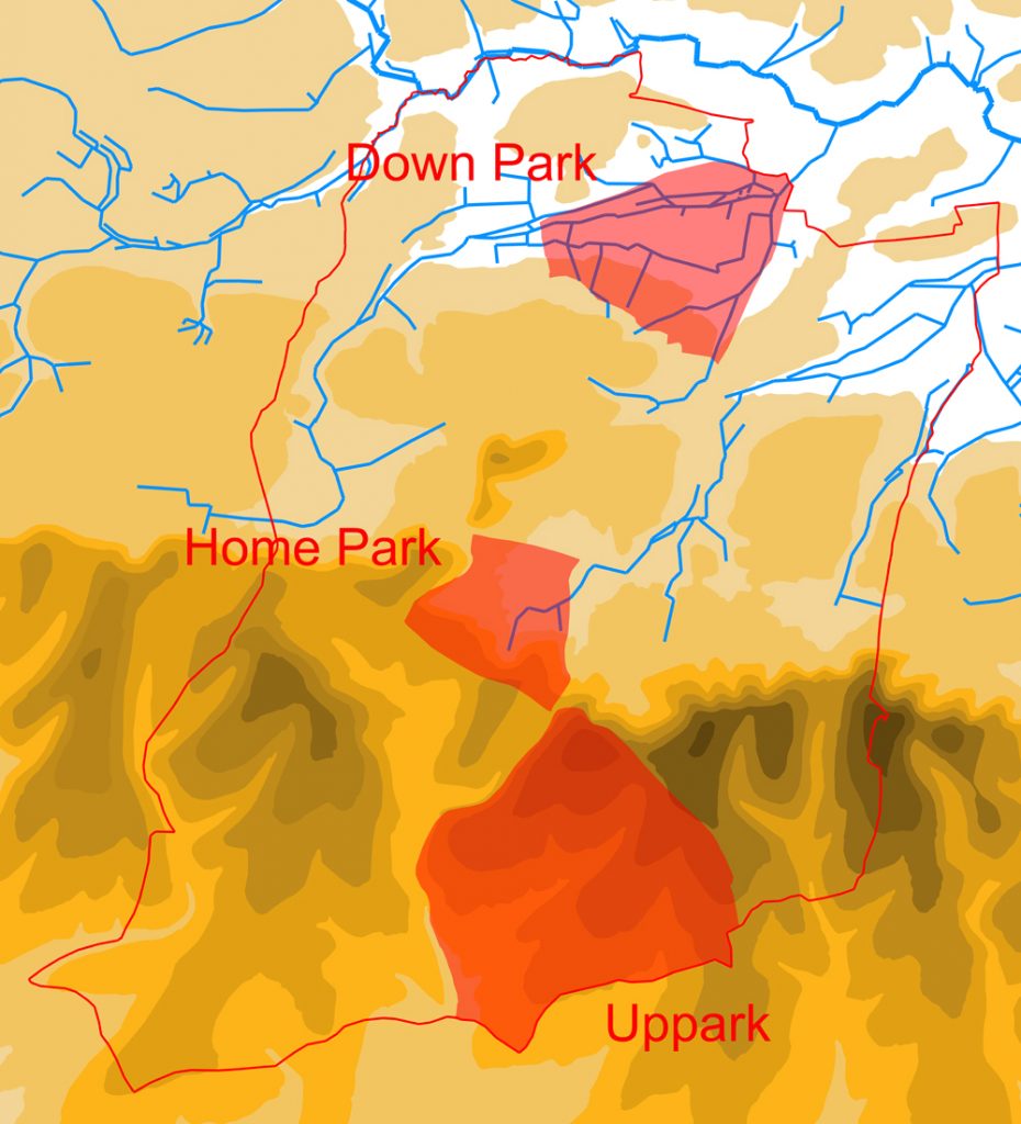
Deer parks were comparatively common in the medieval period, and were owned by a wide variety of individuals, including the monarch and the titled aristocracy, but also archbishops and bishops, and the more minor gentry. Harting seems to have been particularly well served with such parks, the medieval lords of Harting, the Husseys, possessing three, which together totalled about 20% of the land area of the parish.
As the name suggests, the principal purpose of these parks was to hold deer, acting as a sort of “live” larder. There seems to have been a fairly consistent ratio of acres to deer, at least in West Sussex, with the parks of the Earls of Arundel containing roughly one deer per acre (1.1 to be precise). We do not currently have the figures for the number of deer in the Harting parks, but presuming the ratio holds true, and that it was a deliberate figure based upon what they considered at the time your average deer in such parks needed, then the total number of deer in the parish would have been about 1,700.
We tend to have fond notions, based on the movies, about medieval lords going out hunting on a regular basis, on horseback and armed with spears, to kill deer in these parks . But it is far more likely that the killing of the deer in these parks was more often done by the park servants, using cross-bows, whenever venison was required. And, to spoil our imaginary picture even more, it is more probable that when the lords did go hunting, they did so as much using cross-bows as spears, and on foot, as on horses. It may well have had a lot more in common with a modern-day pheasant shoot, than a fox-hunt, with the deer being driven past a number of “stands” behind which lurked an aristocratic huntsman with his trusty 12-bore cross-bow.
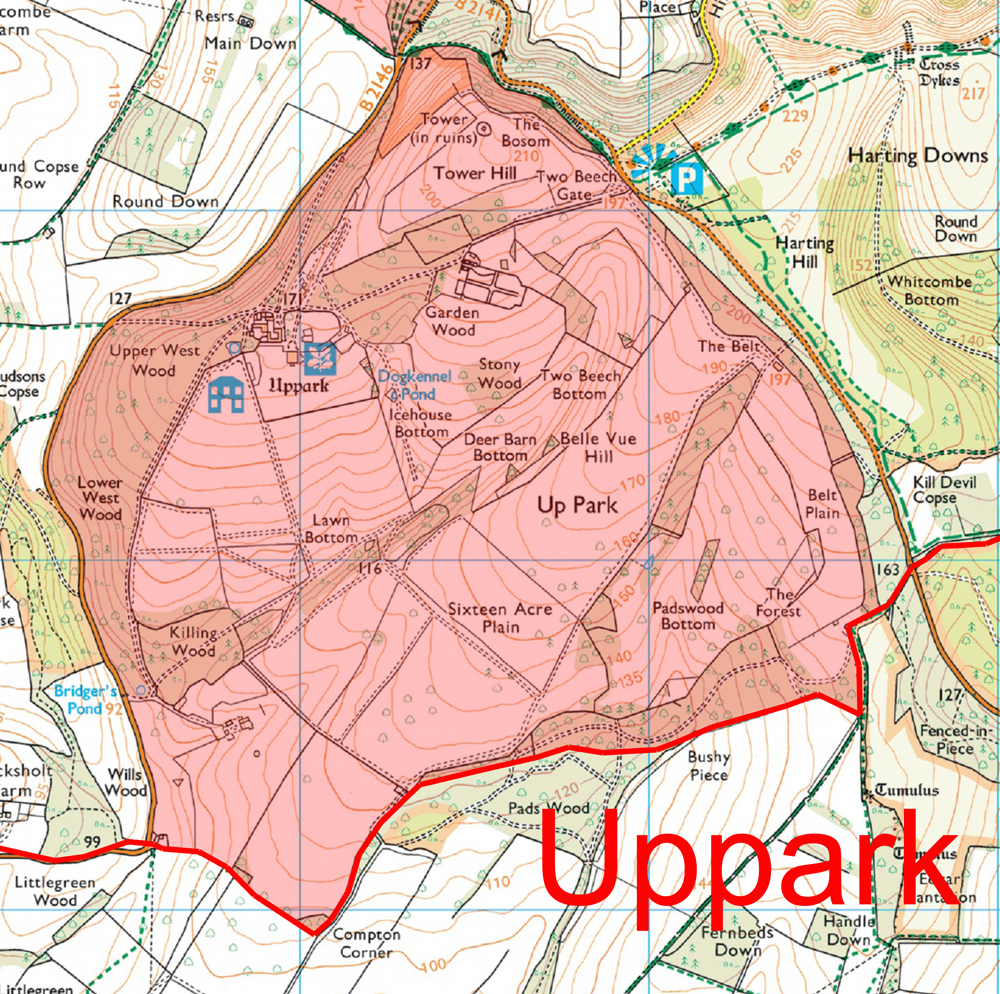
The largest of the three Harting parks is what is now called Uppark, but was in the past known as Overpark or Outrepark. This was situated wholly upon the Downs, and contained something in the region of 900 acres, if its extent on the 1808 map is an accurate record of its medieval size. As with all deer parks, there would have been a hunting lodge within its bounds, most probably on the site of the existing mansion, which was itself built in 1685/6. This lodge would have served as the everyday base of the park keeper, but also as the place to stay for the lord and his guests should they come to hunt. In some cases, as at Downley Park, near Singleton, the lord could turn it into a second home on a more permanent basis. These hunting lodges often went on to become farms or even stately homes when the parks were “disemparked” in the post-medieval period, as happened at Uppark. One of the problems with the park at Uppark would have been water, which was obviously a major issue when you had large herds of deer to look after. There are no natural water sources within the park, and so it had to be supplied in some other way, possibly partly through rain-fed ponds, but also manually from wells. There is such a well, know appropriately as “Keepers Well” within the park. It is also possible that the deer were driven into the neighbouring Home Park, which was separated from it only by the current Uppark road, should things have got desperate.
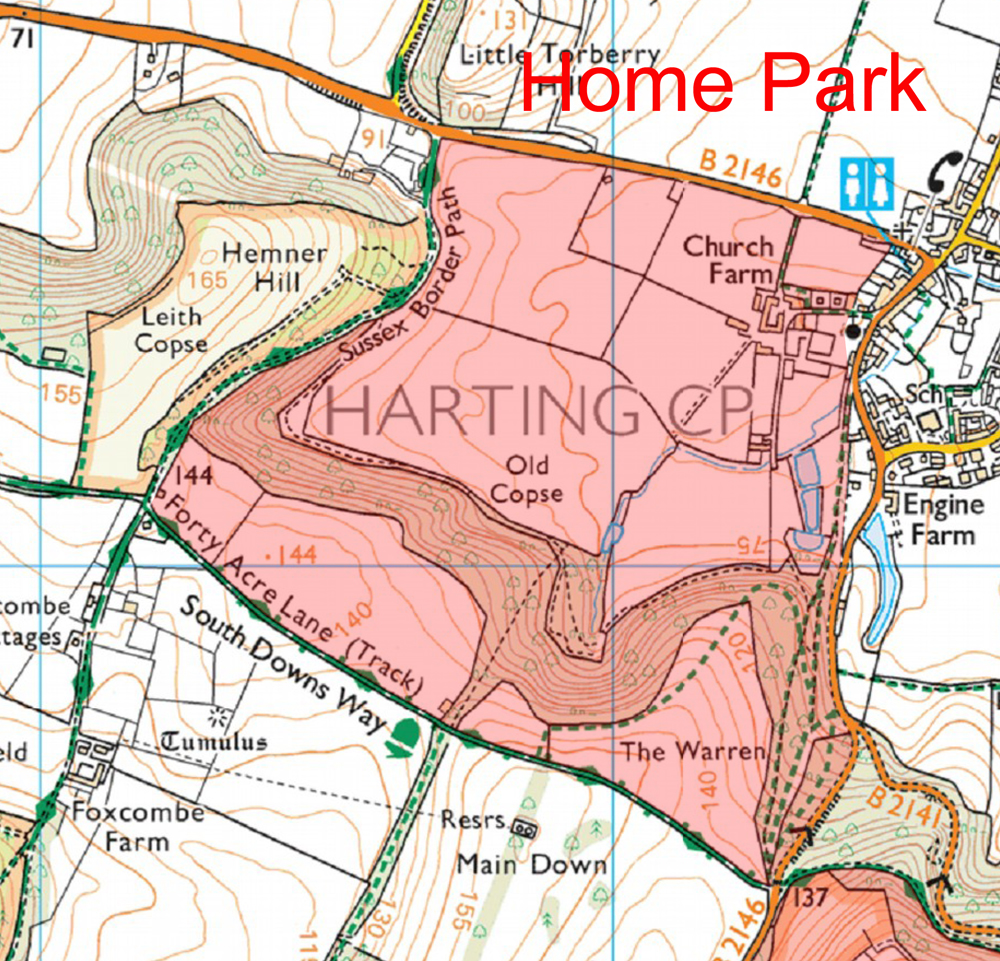
As has just be mentioned, Uppark bordered onto the second of the Harting Parks, that situated adjacent to the manor house and church of South Harting. This was variously known as “Home Park”, “Old Park” or “Middle Park”. It was a much smaller park, presumably because land on the Upper Greensand shelf was much more in demand for cultivation than that elsewhere within the parish. It extended from the current Petersfield road, up to the South Downs Way, being bounded by the Uppark road on one side, and the road to Foxcombe on the other. Altogether it enclosed about 250 acres, and presumably held a similar number of deer (c.275 on the above ratio). Here a hunting lodge was unnecessary, since the manor house and its outbuildings would have served that purpose, sited as they were just within the parks eastern limit. Water was also not a problem, since, as we have already seen in previous blogs, the main eastern stream of the parish began its life within the park.
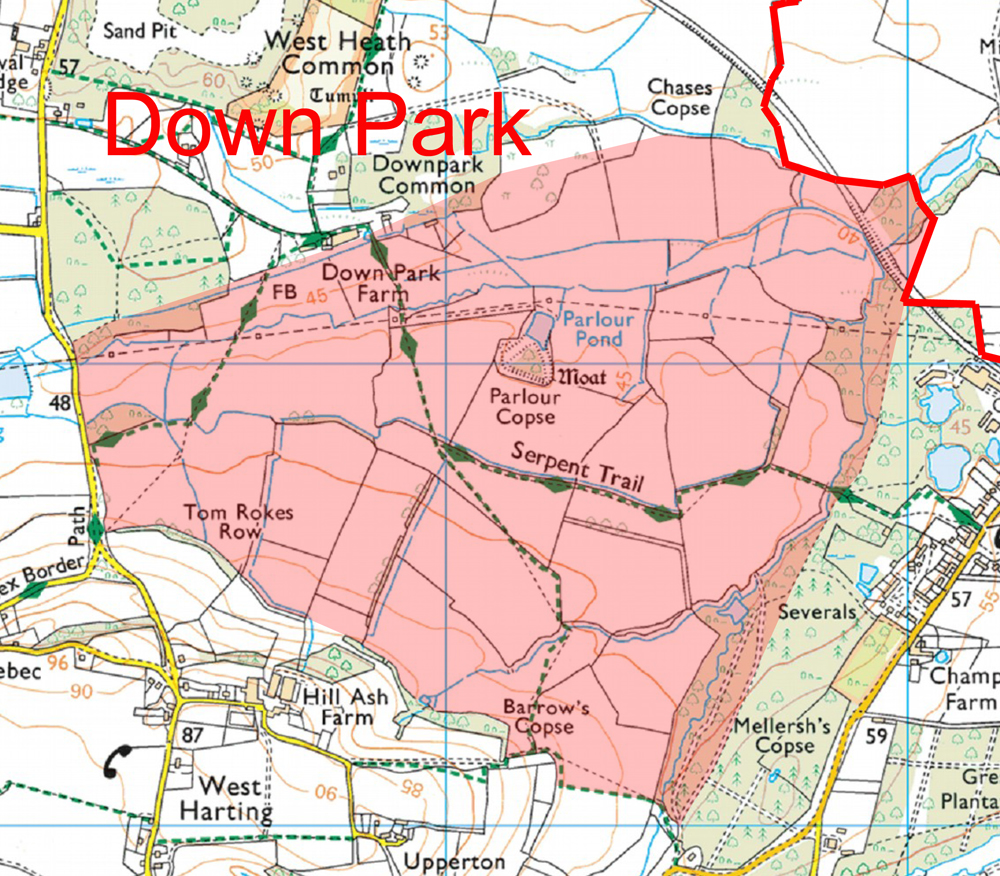
The third and final medieval deer park lay within the northern part of the parish, and was called “Down Park” or “Nether Park” (“nether” being an old word for “lower”). As the name suggests, this park lay in the lowest part of the parish, and certainly did not suffer from water problems. The c.480 deer within its 440 acres would have been well watered by the major West Harting stream and its tributaries, as it meandered through the northern part of the park. Here a hunting lodge would have been required, and it was almost certainly located at Parlour Copse, were a small moat encloses its site. Small-scale excavation of this, back in the mid-20th century, revealed the remains of a timber bridge and significant quantities of roof tiles and pottery dating from the medieval period. This hunting lodge went on to become the main residence of one of the Hussey descendants in the 16th century. As with Home Park, this park may well have also contained a mill, fed by Harting Pond, which itself lay just outside the park to the west. As with all the parks, the idea was that the deer were kept securely inside and not allowed to escape. This was achieved by putting up a fence, called a “pale”, around its entire circuit. The fence was mounted upon a bank, with an internal ditch, to provide enough height to stop the deer leaping over it. Traces of the bank, and occasionally the ditch, if it has not been subsequently infilled, can often still be found around the edges of these deer parks, as is the case with Down Park.
There was a fourth deer park in the parish, but since this was not formed until the 17th century, it is not covered by this blog. It was located on the Downs in the south-western corner of the parish, and surrounded the late 17th century mansion of Ladyholt, once the seat of the Caryll family, and the rival of Uppark, but sadly demolished only a century after its construction.
Leave a Reply