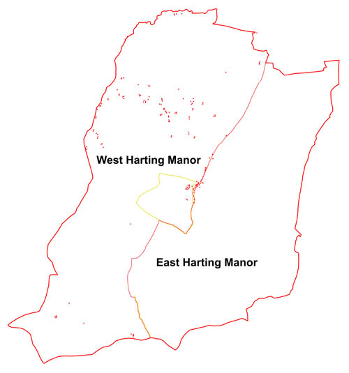
The 1632 Caryll map offers us a fascinating snapshot into life in Harting at this time, or at least to half of Harting, since by this date the old manor of Harting had been split into two – West and East. The term “manor” can be a bit confusing, so it is worth just saying a few words about it. Nowadays we tend to talk of the “manor” as being a building, but actually originally it was an area of land held by one authority, who may well have lived in the “manor house”, i.e. the principal house within the area of the manor. Back in the medieval period the “manor” of Harting was the possession of the Hussey family, but when the male descendants of that family ceased in the late 15th century, the manor got split between two daughters and their husbands, and then descendants, so that by 1568 it had become divided into two halves, West Harting and East Harting, with the dividing line running pretty much north-south along the line of the Nyewood – South Harting – Uppark roads. West Harting had become the possession of the Sir John Caryll who had the 1632 map of his lands drawn up, while East Harting was owned by Sir William Ford, whose wife was actually another Caryll.
West Harting manor included all of what we now refer to as West Harting village, together with the western half of South Harting village, which was rather uncomfortably split down the centre of the High Street between the two manors. When you compare the number and spread of houses shown on the 1632 map with those existing today, what is most striking is the shrinking of West Harting, for there was a significantly larger number of houses four hundred years ago, than there are now. But actually, apart from that, there is surprisingly little change in settlement and landscape. The bulk of the population growth in Harting has actually been in the eastern manor, with the village of Nyewood appearing in the 19th century and the growth of eastern half of South Harting in the 20th century.
I will return to look at West Harting in a later blog, but for the moment we will stick to the main course, which is the central village of South Harting. This was the location of the manor house itself, which lay just to the west of the current church, on the site of what is now Church Farm. It was, in its time, a very impressive set of buildings, with a large crenellated gatehouse facing onto the High Street. Not only did it have a large private garden, of which South Gardens still retains the name, but it was also set within its own private deer park, which extended westwards to the slopes of Hemner Hill, southwards to the summit of the Downs and northwards to the current Petersfield Road
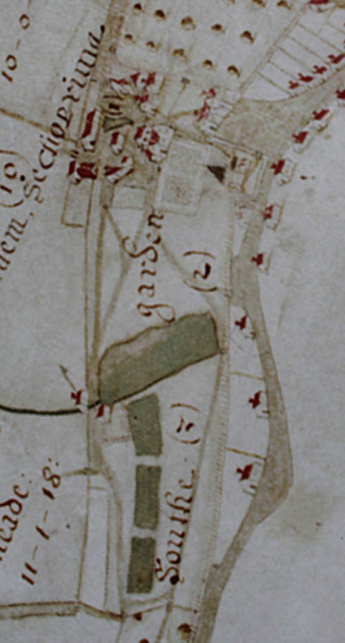
As you can see the Manor House was part of a large complex of buildings, which I may discuss in more detail in a later blog, but the main building is the tallest shown, to the west of the church, with the gatehouse, almost equally big, situated to the north of the church. Between the church and the Manor House lies a walled garden, which now forms part of the churchyard, still enclosed within the same wall. The building lying at the south-west corner of the largest pond (the northern one) may well have been a mill, powered by the water held back in the upper three ponds. This building does not survive
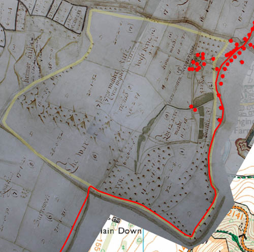
The deer park was not a large one by contemporary standards, but would have been well stocked with deer, probably numbering in the hundreds. Its purpose was to act as a living larder for the benefit of its owners, and also as a source of gifts to those they wanted to favour. By the date of our map, such parks were losing their original function, and being turned over to agriculture – hence the subdivisions into fields, which would not have existed a century or so before. The park as a whole was surrounded by a fence, known as the “pale”, to keep the deer in, and this fence is still marked on the map, even though the park has ceased to be a proper deer park.
In the next blog we will look at another aspect of the 1632 map.
Leave a Reply